Japan’s zoning rules help determine what a property can be used for and what can be built on its land. For a buyer, the key checks are the land-use zone, building coverage ratio, floor-area ratio, legal road access and additional local restrictions. Together, these affect whether a property fits your plan to live there, rebuild or change its use.
This guide explains the terms you may encounter in a Tokyo listing, with an illustrative calculation and a checklist for discussing a property with your agent and architect. It draws on Japan’s Ministry of Land, Infrastructure, Transport and Tourism (MLIT) and official municipal guidance.
Read zoning as several layers of rules
A land-use zone, or yoto chiiki (用途地域), sets rules for the types of buildings and activities allowed in an area. It sits within a broader planning system. Where an area is divided into urbanization promotion and urbanization control areas, that distinction also matters: development in an urbanization control area is restricted in principle, with specific exceptions and permission requirements.
Local districts and plans add another layer. A zoning label therefore cannot answer every question about a particular plot. For an existing condominium, also review the building’s records and management rules. The site’s zoning does not give an individual unit owner an independent right to extend or redevelop the building.
Japan currently has 13 land-use zones
The categories fall broadly into residential, commercial and industrial groups. The table below groups all 13 for easier reading; it is an overview, rather than a complete list of permitted building uses.
A residential designation does not promise a completely residential street, and a commercial designation does not automatically rule out a home. Check the particular use, its scale and any local modifications to the general rules.
Building coverage ratio and floor-area ratio measure different things
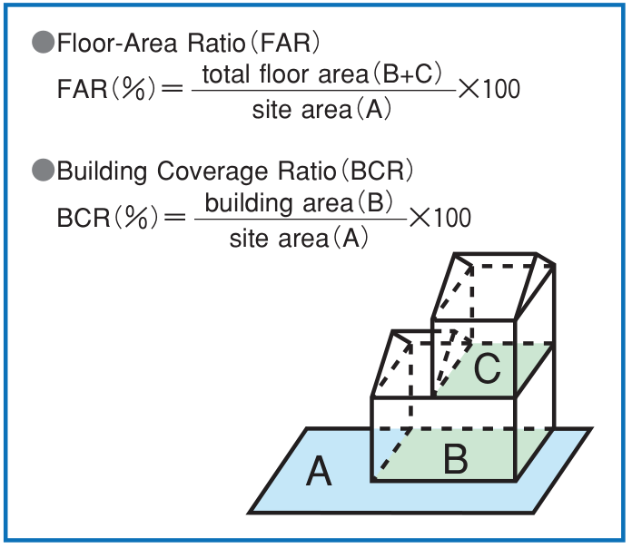
建ぺい率 · kenpeiritsuBuilding area ÷ site area × 100. Think of building area as the legally measured footprint, rather than the sum of all floors.
容積率 · yosekiritsuTotal floor area counted for FAR ÷ site area × 100. The calculation can differ from other floor-area figures because specific exclusions may apply.
An example: a 100 m² site with 60% BCR and 200% FAR
Assume the full 100 m² is usable as the building site, with no road setback deduction. Before considering other rules, the coverage calculation is 100 × 60% = 60 m², and the FAR calculation is 100 × 200% = 200 m².
Now suppose the adjoining road is 4 metres wide and the applicable road-width multiplier is 0.4. The road-based FAR limit is 4 × 0.4 = 1.6, or 160%. In this simplified example, the lower 160% limit applies, giving 160 m² of floor area counted for FAR.
100 m²No setback deduction in this example.
60 m²100 m² × 60% building coverage.
160 m²100 m² × 160% FAR, before further design constraints.
The road-width rule generally concerns roads under 12 metres wide, and the applicable multiplier varies by zone and local designation. These figures illustrate the calculation, not an approved building plan. Height, shadows, the site’s shape and other requirements can prevent a design from using the full allowance. Any relaxation or floor-area exclusion must also be checked for the actual project.
Check legal road access and any required setback
A visible street is not enough to establish buildability. Under the general road-access rule, a building site must have at least 2 metres of frontage onto a road recognized under the Building Standards Act. Some building types and sizes require more. Exceptional routes require their own checks; do not assume they apply to a property you are considering.
Certain narrow roads recognized under Article 42(2) require a setback when building. In the usual situation, the boundary is set back to 2 metres from the road’s centerline, although the method can differ with site conditions. The portion treated as road cannot be included in the building site area used for the coverage and FAR calculations.
Keep that answer separate from the total land area in the advertisement. If your purchase depends on rebuilding, establish the road and setback position before relying on the existing house’s size.
Height controls and district plans can change the feasible design
Floor-area ratio is an area limit, not a height entitlement. Absolute height limits, height-control districts, slant-plane restrictions and shadow rules can shape a building differently even where the same FAR is designated. Slant-plane restrictions relate allowable height to distances from roads or site boundaries; shadow rules protect sunlight under specified conditions.
A district plan can add rules for a smaller neighborhood, including uses, minimum plot sizes, wall positions or building height. Also check fire protection designations and planned urban roads. Incentive systems that relax some controls exist, but they depend on their own conditions and approvals and should not be assumed in a purchase calculation.
For a home you intend to occupy, examine the neighboring plots as well. Today’s low building or open view is a description of current conditions, not a guarantee of what may be built there later.
Turn a listing into a property-specific checklist
Two similarly priced plots near the same station may support very different plans. Start with the exact parcel and your intended use, then organize the checks below before making a decision.
- Confirm the location and boundaries. Match the listing, parcel information and available survey documents.
- Record the planning designations. Identify the land-use zone, designated BCR and FAR, and applicable local districts.
- Check the road. Confirm legal classification, width, frontage and any setback.
- Check the usable building allowance. Apply the relevant site area and road-based FAR limit, then review height and other restrictions.
- Test your actual plan. Ask an architect to assess the intended floor space and use, especially if buying to rebuild.
- Clarify unresolved points before contract. Identify what the agent, architect and municipal office each need to confirm.
For Itabashi properties, the ward’s official planning guidance links to its zoning and city-planning maps. Use those as a starting point and confirm site-specific questions with the relevant department. For Toshima, Nerima, Kita or another municipality, check that municipality’s own current maps and rules.
See our Tokyo buying support or follow the full process in our guide to buying property in Japan. For the neighborhood perspective, read Living in Itabashi.
Official sources and scope
Sources checked on 5 October 2026. This is a general reading guide; property-specific buildability and design require confirmation against the rules applying to the actual site and proposed work.
FAQ
Frequently asked questions
What is the difference between building coverage ratio and floor-area ratio in Japan?
Building coverage ratio (kenpeiritsu) compares the building’s legally measured footprint with the site area. Floor-area ratio (yosekiritsu) compares the total floor area counted for that regulation with the site area. A 60% coverage limit and 200% FAR on a 100 m² site give initial figures of 60 m² and 200 m² respectively, before other restrictions and any applicable adjustments.
Does a 200% floor-area ratio mean I can build 200 m² on 100 m² of land?
Not necessarily. That is the initial calculation using the designated ratio. The adjoining road can impose a lower FAR limit, and setbacks, height controls, shadow rules and the shape of the site may further constrain the design. Ask an architect to assess the specific site and your intended building.
Does Japan have 12 or 13 land-use zones?
Japan currently has 13 land-use zone categories, including the rural residential zone (田園住居地域). Older English brochures may show only 12. Check current official information and the actual designation for the property.
Can I assume an existing house can be rebuilt at the same size?
No. The presence and size of an existing house do not establish the permitted size of a replacement. Road access, setback requirements and the controls applying to a new building need a separate check before you rely on a rebuilding plan.